Massachusetts Division of Marine Fisheries Bottom Trawl Survey
Massachusetts’ coastal waters are inhabited by diverse and productive communities of fishes and invertebrates that contribute to state and regional fisheries. The Massachusetts Division of Marine Fisheries, as part of its responsibility to manage the Commonwealth’s living marine resources, has conducted spring and fall trawl surveys since 1978 with the intent of quantifying the distribution, relative abundance, and size composition of finfish and select invertebrates within the territorial waters of Massachusetts (inclusive of Nantucket Sound).

Survey Design
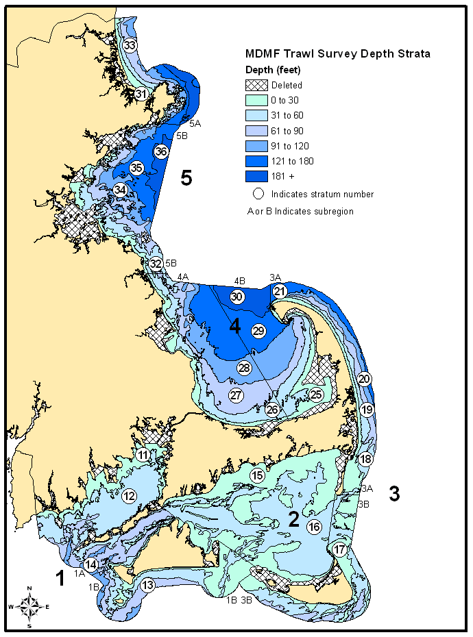
The study area is stratified based on five bio-geographic regions and six depth zones (Figure 1). Depth strata are based on lines of bathymetry or interpolation of soundings of mean low water on NOAA charts. The shallowest strata, defined as less than 9.1 m (<30 ft) is functionally bound by the safe limits of operating the research vessel in shallow depths. The deepest strata (30 and 36), defined as greater than 55m (>180 ft), are restricted by the limits of the state territorial waters. Sampling intensity is approximately 1 station per 19 nm². The total area of each stratum is used to assign stations proportionally, with each stratum having a minimum of two (Figure 2). In 2005, station assignments were updated to reflect improved stratum area estimates. A net addition of two stations resulted in a total of 103. Survey timing is planned for availability of adult finfish in the inshore waters in spring (May) while the fall survey (September) is intended to sample juveniles prior to migration beyond state waters.
Since 1982, stations have been assigned a priori by a random selection process. Any randomly selected station that is identified as being on untowable bottom is rejected and another random selection is drawn. Previous failed attempts at towing and side scan sonar images are used to inform decisions about untowable bottom. Hard bottom habitats identified as untowable from previous experience have effectively been removed from the station selection process.
All tows are conducted during daylight hours. A standard tow of 20 minutes duration at a speed of 2.5 knots is executed after reconnaissance at each site to ensure a clear path. Catch data from tows of ≥ 13 minutes, but <20 minutes are expanded to the 20-minute standard and coded as acceptable. Both standard and acceptable tows are considered representative for all species. Tows of less than 13 minutes or tows with significant obstruction or gear damage are considered non-representative and are excluded. The only exception has been the use of tows less than 13 minutes for spiny dogfish abundance estimates. This only applied when catches were large enough to fill the net prior to reaching the 13-minute mark.
Standard bottom trawl survey techniques are used when processing the catch. Total weight and length frequencies are recorded for each species using the Northeast Fisheries Science Center’s (NEFSC) Fishery Scientific Computing System (FSCS). Sampling protocols and survey design follow the methods established by the NEFSC. Total weights are recorded to the nearest 0.01 kg for each species. Lengths for each species are measured according to the methods listed in Table 1. Homarus americanus, Cancer borealis, Cancer irroratus, Callinectes sapidus, Limulus polyphemus, Busycotypus canaliculatus, and Busycon carica, are measured to the nearest mm. All other lengths are recorded to the nearest cm.

Survey Vessels and Sampling Gear
Surveys from 1978 - 1981 were conducted aboard the F/V Frances Elizabeth and all subsequent surveys have employed the NOAA R/V Gloria Michelle (Figure 3). Trawl design and trawl doors have been consistent for the duration of the survey. The net is a ¾ size North Atlantic type two seam otter trawl (39’headrope/51’ footrope) rigged with a 3.5” rubber disc sweep and a ¼” knotless codend liner (1/2” stretched mesh) (Figure 4). The survey trawl is spread behind 72” x 40” 325 lb wooden trawl doors; 63’, 3/8” chain bottom legs; and 60’, 3/8” wire top legs (Figure 5).

Contact Information
Data requests and inquiries about survey information can be sent to Steve Wilcox.
Massachusetts Division of Marine Fisheries
Resource Assessment Project
Trawl Survey Updates
